The day before an avalanche of ice, rocks and muddy water swept through the Himalayan valleys along the border between Nepal and China, Dipesh Chapagain was talking with a colleague about how devastating a disaster of that magnitude could be.
For this 40-year-old climate researcher, who grew up in the hills of eastern Nepal and now studies mountain hazards at the United Nations University in Bonn, Germany, the issue was both professional and deeply personal.
Throughout his own life he has seen how the risks facing the region have changed.
“When I was a child, it wasn’t like that,” he recalled. “Nor was it like that when my parents or grandparents were children. That wasn’t the main challenge they faced.”
A glacier gives way, a mountain collapses
Then, on Wednesday morning, at 8:37, a hillside high in the Himalayas collapsed.
The collapse was so powerful that seismic instruments recorded it as a magnitude 5,2 event , initially mistaking it for an earthquake. The bedrock beneath a glacier gave way, dragging a massive amount of ice and rock some 1200 meters to the valley floor.
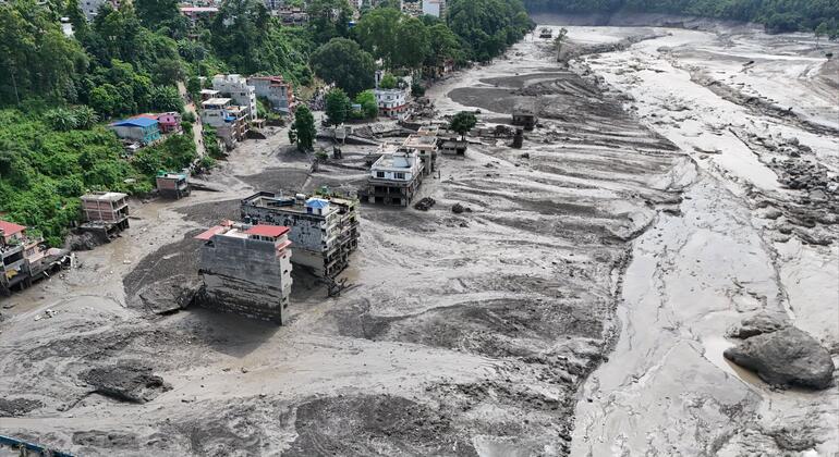
Water, sediment, and enormous rocks rushed into the rivers, devastating towns and villages along one of the most important trade routes between Nepal and China. At one monitoring station, the water level rose by nine meters in just half an hour.
By Friday, more than 500 deaths had been reported in Nepal and Tibet, and more than 1500 people remained missing , including hundreds of foreign nationals.
Chapagain's immediate family was unharmed. Even so, receiving the news affected him deeply.
“It’s always difficult to receive these devastating messages from my country,” he said. “It’s happening more frequently and with greater intensity.”
The catastrophe brutally illustrates a problem that climate scientists have been warning about for years. The icy structure of the Himalayas is changing , exposing millions of people to increasingly unpredictable and, in some cases, more destructive hazards.
How a mountain landslide turned into a deadly flood
Experts are still trying to reconstruct the sequence of events that led to Wednesday's disaster. Analysis of satellite images suggests that the bedrock beneath a glacier gave way, causing a massive mass of ice and rock to tumble into the Lhende Khola, a tributary of the Bhotekoshi River, and trigger the destructive chain of events that followed.
The mechanism was different from that of the floods caused by the sudden overflow of glacial lakes that Chapagain and his colleagues study throughout the Hindu Kush-Himalaya region through the Global Mountain Safeguard (GLOMOS) research program, belonging to the United Nations University's Environment and Human Security Institute.
A recent investigation by the program analyzed 493 such floods , from the earliest available records to 2024. The results show that these events have become approximately five times more frequent since 1950 , rising from an average of around seven per decade to 34.
These floods typically occur when meltwater accumulates in lakes around retreating glaciers, often held back by unstable barriers of ice, loose rock, or sediment. When these natural dams break, enormous volumes of water can be released almost instantaneously.
However, Wednesday's disaster appears to have followed a different sequence.
“This time he skipped the intermediate step,” Chapagain explained.
Instead of a glacial lake overflowing, a mass of rock and ice broke off from the mountain and created a torrent in the lower areas. Researchers are now studying whether the debris temporarily blocked the river before the barrier gave way, although Chapagain cautioned that this sequence has not yet been confirmed.
For scientists, the difference is important. But downstream, the result can look terrifyingly similar: a huge volume of water, ice, and debris released almost without warning into narrow, inhabited valleys.
It is unclear whether climate change caused Wednesday's landslide. However, global warming is rapidly transforming the high-altitude environments where these disasters occur. As glaciers melt and permafrost thaws, rocks that were once held or bound by ice can become unstable, while increased meltwater can further weaken slopes.
The consequences extend far beyond mountain communities. The Hindu Kush-Himalaya feeds ten major river basins upon which some 2100 billion people depend for water, food, energy, and livelihoods.
More and more people are settling in high-risk areas
But the mountains aren't the only thing that's changing. The geography of human life beneath them is also being transformed.
When Chapagain was a child, he explained, families in many mountainous areas of Nepal traditionally built their homes on the higher parts of the hillsides, while cultivating rice and other crops on flatter land near the rivers. His own family's vegetable garden was high up on a mountain; the rice paddies were below, near the river.
Over time, roads, businesses, hotels, and hydroelectric projects have become increasingly concentrated in river valleys, where construction is easier and economic opportunities are greater. Water sources for some settlements located in higher elevations have also dried up, Chapagain noted, forcing residents to relocate to lower-lying areas.
This has created a dangerous convergence: while warming transforms the mountains, more and more people and infrastructure are concentrating in the corridors through which water and debris flow down.
The valley devastated by Wednesday's flooding reflects that collision. The Bhote Koshi-Trishuli corridor is home to a vital trade route to Kathmandu and is lined with hydroelectric power plants, bridges, roads, hotels, and settlements. The floods damaged electrical infrastructure and disrupted transportation and communication links throughout the region.
The danger had already given warning signs. Last year, the sudden overflow of a glacial lake affected the same river system, causing nine deaths and leaving 24 missing.
When every minute counts
For Chapagain, Wednesday's catastrophe also exposed a fundamental weakness: the limited warning time communities have before a disaster originating high in the mountains reaches them.
According to reports, Nepalese authorities only learned of the flooding when it was already approaching the border. Alerts were then relayed downstream via text messages, social media, phone calls, and alarms.
Reducing the danger, he argues, requires starting much higher up: continuously monitoring glaciers and unstable slopes, using satellite observations, having weather stations and river gauges, and having early warning systems capable of giving communities enough time to evacuate.
Furthermore, since rivers and glaciers cross national borders, China, Nepal, and downstream countries need to exchange information quickly.
There is also a deeper problem. Even if greenhouse gas emissions were to decrease drastically, Chapagain explained, glaciers would continue to lose mass for decades due to the warming already built into the climate system.
Humanity can still influence how much ice will ultimately be lost. However, it has far less control over what will happen in the immediate future.
Therefore, for Chapagain, adaptation can no longer be understood as a preparation for a distant future.
For the communities living below the Himalayas, that future arrived on Wednesday.